| タウポ湖 |
|---|
|
所在地 |
ニュージーランド北島
|
|---|
面積 |
616 km2
|
|---|
周囲長 |
193 km
|
|---|
最大水深 |
186 m
|
|---|
淡水・汽水 |
淡水湖
|
|---|
湖沼型 |
カルデラ湖
|
|---|
 プロジェクト 地形 プロジェクト 地形
|
| テンプレートを表示 |
 |
ウィキメディア・コモンズには、タウポ湖に関連するカテゴリがあります。 |
座標: 南緯38度49分 東経175度55分 / 南緯38.817度 東経175.917度 / -38.817; 175.917
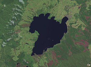
タウポ湖(Lake Taupo)は、ニュージーランド北島のタウポに位置する、ニュージーランド最大の表面積(616km²)を持つ湖。
西暦181年の巨大噴火(VEI7、噴煙高度50km)によってできたカルデラ湖。付近では現在も火山活動が活発で、温泉や地熱発電所がある。
26,500年前には、VEI8の巨大噴火(Oruanui eruption、噴出量は1170立方km、過去7万年で最大規模)を起こしている。
ワイカト川が流れ出ている。
鰻、鱒などが生息。
タウポ湖畔マイン・ベイの南端の断崖には、マオリの彫刻がある。
文献
Ben G. Mason; David M. Pyle, and Clive Oppenheimer (2004). “The size and frequency of the largest explosive eruptions on Earth” (PDF). Bulletin of Volcanology 66 (8): 735-748. doi:10.1007/s00445-004-0355-9. https://doi.org/10.1007/s00445-004-0355-9 2006年7月14日閲覧。.
関連項目
外部リンク
- Destination Lake Taupo
- Turangi and Lake Taupo Website
- Lake Taupo Webcam
- Taupo Volcanic Zone
- History and legends of Lake Taupo
Lake Taupo water quality (includes bathymetric map)
- Flickr.com Photos tagged with laketaupo & taupo
大噴火(VEI7以上、*はVEI8、kaは1,000年前、Maは100万年前を示す単位)
|
|---|
ベネット(英語) (50Ma) |
スカコム(英語版)
ラガリータ (27.8Ma)* |
メイリースベイル(英語版) (23Ma) |
メイリースベイル(英語版) (19Ma) |
イエローストーン (16.548Ma) |
イエローストーン (15.8Ma) |
イエローストーン (15.7Ma) |
イエローストーン (15.6Ma) |
イエローストーン (15.6Ma) |
イエローストーン (15Ma) |
南西ネバダ (13.25Ma) |
南西ネバダ (13Ma) |
南西ネバダ (12.8Ma) |
南西ネバダ (12.7Ma) |
南西ネバダ (11.6Ma)* |
南西ネバダ (11.45Ma) |
イエローストーン (11Ma)* |
パストス・グランデス(英語版) (8.3Ma) |
南西ネバタ (7Ma) |
イエローストーン (6.62Ma)* |
セロ・グアチャ(英語版) (5.7Ma)* |
イエローストーン (4.45Ma)* |
パカナ(英語版) (4Ma)* |
セロ・グアチャ(英語版) (3.5Ma) |
パストス・グランデス(英語版) (2.9Ma) |
イエローストーン (2.2Ma)* |
ガラン(英語版) (2.2Ma)* |
玉川 (2Ma) |
タティオ(英語版) (1.9Ma) |
十勝 (1.9Ma) |
アティトラン (1.8Ma) |
バイアス(英語版) (1.78Ma) |
穂高 (1.75Ma)* |
ボルシェ・バナイヤ (1.7Ma) |
マンガキノ (1.63Ma)* |
バイアス(英語版) (1.47Ma) |
小野 (1.4Ma) |
マンガキノ (1.4Ma) |
イエローストーン (1.3Ma) |
マンガキノ (1.24Ma)* |;
バイアス(英語版) (1.15Ma) |
ベイカー (1.149Ma) |
カリムスキー(英語版) (1.13Ma) |
十勝 (1.1Ma) |
マンガキノ (1.01Ma)* |
十勝三股 (1Ma) |
玉川 (1Ma) |
成岡 (1Ma) |
猪牟田 (1Ma) |
コルベッティ(英語版) (1Ma)* |
マンガキノ (970ka) |
トバ (840ka) |
カラボソス(英語版) (800ka) |
ロングバレー(英語版) (759ka)* |
アカトラン(英語版) (650ka) |
イエローストーン (640ka)* |
霧島 (600ka) |
ラナウ(英語版) (550ka) |
オカタイナ(英語版) (550ka) |
小林 (525ka) |
コルベッティ(英語版) (500ka) |
姶良 (500ka) |
コパウエ (500ka) |
ロスメロス(英語版) (460ka) |
姶良 (456ka) |
ディアマンテ(英語版) (450ka) |
白頭山 (446ka) |
ブラッチャーノ(英語版) (374ka) |
ラツィアーレ(英語版) (360ka) |
マロア (335ka)* |
加久藤 (325ka) |
カラボソス(英語版) (300ka) |
ブルシーニ (300ka) |
マニンジャウ(英語版) (280ka) |
ハロハロ (280ka) |
オカタイナ(英語版) (280ka) |
阿多 (240ka) |
シャラ(英語版) (240ka) |
レポロア(英語版) (230ka) |
マロア (230ka) |
オカタイナ(英語版) (225ka) |
ロトルア (220ka) |
阿寒 (175ka) |
イエローストーン (173.1ka) |
コス (161ka) |
カラボソス(英語版) (150ka) |
阿蘇(Aso3) (130ka) |
屈斜路 (117.5ka) |
洞爺 (114ka) |
阿多 (105ka) |
ブルシーニ (100ka) |
鬼界 (95ka) |
阿蘇(Aso4) (90ka) |
アティトラン (84ka) |
トバ (73ka)* |
マニンジャウ(英語版) (52ka) |
オカタイナ(英語版) (50ka) |
ネオピーク (45ka) |
オパラ(英語版) (45ka) |
支笏 (44ka) |
ウゾン(英語版) (42ka) |
クリル湖(英語版) (41ka) |
イロシン (41ka) |
ポアス(英語版) (40ka) |
屈斜路 (39ka) |
ゴレーリ(英語版) (39ka) |
フレグレイ (37ka) |
姶良 (30ka) |
タウポ (26.5ka)* |
セミソポシュノイ(英語版) (9.95ka) |
クリル湖(英語版) (8.455ka) |
クレーターレイク (7.692ka) |
鬼界 (7.2ka) |
セロ・ブランコ(英語版) (4.3ka) |
ミノア (BC1628) |
タウポ (181) |
白頭山 (942±4) |
リンジャニ (1257) |
タンボラ (1815)
|
|
 Mixing


